

SYNOPSIS:
Fresh north northeasterly winds and rough seas are expected across the Cayman area for the next 24 hours as a cold front moves southeast of the Cayman area and a high pressure system builds over the southern United States.
Radar images show isolated showers in and around the Cayman area moving towards the southwest.
FORECAST:
Today: Partly cloudy to cloudy skies with a 20% chance of morning showers. Temperatures will rise to the low 80’s °F. Winds will be north to northeast 15 to 20 knots with higher gusts. Seas will be rough with wave heights of 5 to 7 feet especially along the west and north coasts. Small craft should exercise caution over open waters. Some swells are likely along the west and north coasts.
Tonight: Partly cloudy skies with a 20% chance of showers. Temperatures will fall to the low 70’s °F. Winds will be north to northeast 15 to 20 knots. Seas will be rough with wave heights of 4 to 6 feet especially along the west and north coasts. Small craft should continue to exercise caution over open waters. Some swells are likely along the west and north coasts.
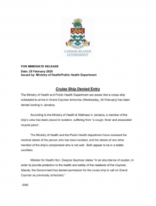
The Ministry of Health and Public Health Department are aware that a cruise ship scheduled to arrive in Grand Cayman on Wednesday, 26 February, has been denied entry in Jamaica.
Minister for Health Hon. Dwayne Seymour states “In an abundance of caution, in order to provide protection to the health and safety of the residents of the Cayman Islands, the Government has denied permission for the cruise ship to call on Grand Cayman as previously scheduled.”
Valid for the morning of February 01st 2020 through the morning of February 02ND 2020.
Light and variable winds and smooth seas will continue across the Cayman area for the next 24 hours in association with a slack pressure gradient over the northwest Caribbean. Further north, a cold front over the southeast Gulf of Mexico will move into the Cayman area tomorrow morning. Radar images show isolated showers in and around the Cayman area moving northwest.
FORECAST:
Today: Partly cloudy skies becoming cloudy at times with a 30% chance of showers. Temperatures will rise to the mid 80’s °F. Winds will be light and variable. Seas will be smooth with wave heights of less than 2 feet.
Tonight: Cloudy skies with a 40% chance of showers. Temperatures will fall to the low 70’s °F. Winds will be light and variable this evening becoming northwest 5 to 10 knots from late tonight. Seas will be smooth to slight with wave heights of 1 to 3 feet. Some swells are likely along the west coasts from this evening.
Valid for the evening of January 31st 2020 through the evening of February 01st 2020.
SYNOPSIS:
Light easterly winds and smooth seas will continue across the Cayman area for the next 24 hours in association with a slack pressure gradient over the northwest Caribbean. Radar images show no showers over the Cayman area.
FORECAST:
Tonight: Fair skies with a less than 20% chance of showers. Temperatures will fall to the low 70’s °F. Winds will be southeast at 5 to 10 knots. Seas will be smooth with wave heights of less than 2 feet.
Tomorrow: Partly cloudy skies with a less than 20% chance of showers. Temperatures will rise to the mid 80’s °F. Winds will be light and variable becoming north northeast at 5 to 10 knots by the afternoon. Seas will be smooth with wave heights of less than 2 feet.
With the seas subsiding, the Port of GT is now reopened. Cruise Operations today will occur at Spotts, but cargo operations will be permitted to resume at the Port of GT today
Valid for the afternoon of January 22ND 2020, through the afternoon of January 23Rd 2020.
SYNOPSIS: Moderate to fresh north to northeasterly winds and moderate to rough seas expected over the Cayman area for the next 24 hours in association with a high pressure system over the southeast United States. Radar images show scattered showers in and around the Cayman area.
FORECAST:
Today: Cloudy skies with a gradual decrease in cloudiness by evening with a 20% chance of showers. Temperatures will rise to the low 80’s °F. Winds will be north northwesterly 15 to 20 knots with higher gusts. Seas will be rough with wave heights of 5 to 7 feet. Small craft should continue to exercise caution over open waters. Swells are expected along the west and north coasts.
Tonight: Partly cloudy skies with less than 20% chance of showers. Temperatures will fall to the mid 70’s °F. Winds will be north to northwest at 15 to 20 knots. Seas will be rough with wave heights of 4 to 6 feet. Small craft should exercise caution over open waters from evening. Swells are expected along the west and north coasts.
Tomorrow: Mainly fair skies during the day becoming partly cloudy at night with less than 20% chance of showers. Temperatures will rise to the low 80’s °F. Winds will be north northwesterly 10 to 15 knots. Seas will be moderate with wave heights of 3 to 5 feet.
OUTLOOK: is for moderate north to northeasterly winds and slight seas will continue through to Friday afternoon as the pressure gradient over the northwest Caribbean continues to slacken.
FORECASTER: Forbes/Porter
As of 10am, 20.1.20, the Port of George Town is closed until further notice due to weather. Cruise Ships will tender at Spotts as weather permits.
FORECAST:
Today: Partly cloudy skies with cloudy spells and a 30% chance of showers. Temperatures will rise to the mid 80’s °F. Winds will be east to northeast 15 to 20 knots becoming 10 to 15 knots by afternoon.Seas will be rough with wave heights of 4 to 6 feet. Small craft should exercise caution over open waters.
Tonight: Partly cloudy skies with cloudy spells and a 30% chance of showers. Temperatures will fall to the mid 70’s °F. Winds will be east to northeast at 15 to 20 knots. Seas will be rough with wave heights of 4 to 6 feet. Small craft should exercise caution over open waters.
OUTLOOK: is for an increase in cloudiness and showers over the Cayman area from Monday morning as a cold front moves over the Yucatan Channel and the associated pre frontal trough extends over our area.

What to do when your shipment arrives in Grand Cayman Procedures you have to go through before receiving your shipment. You can decide to clear the shipment yourself or appoint a broker to do so on your behalf.

Ship your cargo using any of the shipping companies or one of the agents. For Importing and Exporting of Cargo to/from Cayman brac Thompson Shipping is the only agent/company to import and export freight from Cayman Brac. You may contact them for further information.